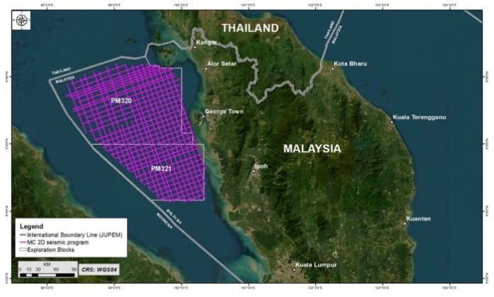
Petronas has undertaken a new offshore multi-client 2D seismic survey in the northern area of the Straits of Melaka to explore and map the hydrocarbon potential in the open blocks of PM320 and PM321 of the Langkasuka Basin.
The survey it said will increase the availability of a larger pool of seismic data, leading to a higher probability of discovering hydrocarbon potential which, in turn, is expected to attract prospective investors in future bid rounds.
This ongoing seismic survey was initiated in October 2023 and is set to conclude in late December this year. It covers an area of over 38,000 square kilometres with the aim of acquiring approximately 8,000 kilometres of new 2D seismic data. It is designed to provide superior quality seismic data for prospecting the pre-Tertiary targets.
Senior Vice President of Malaysia Petroleum Management (MPM), Mohamed Firouz Asnan said, “PETRONAS continues to invest in data enrichment for Malaysian basins, like the emerging Langkasuka Basin. Initiatives such as this multi-client seismic survey is expected to attract exploration interests to support the country’s production growth strategy.”
Azmir Zamri, Senior General Manager of Resource Exploration MPM, added “Our recent study of the Langkasuka Basin indicates hydrocarbon potential in the untested deeper pre-Tertiary formation, which prompted for this seismic survey to be conducted. The first exploration probe is expected in the next three years to test this exciting new geological play.”
MPM is the custodian of the petroleum resources in Malaysia, with this mandate, MPM manages petroleum arrangements and provides stewardship on upstream exploration and production activities in Malaysia.


